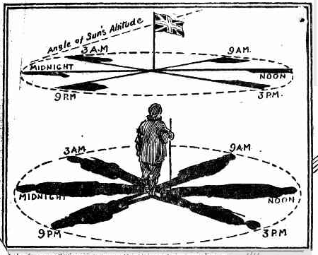
In this article I present an infographic from the era of polar exploration, this appeared in both the Sunday Times of 8 March, 1914 and The Globe of 14 March 1914. I think it could be best understood as an advertorial.
The infographic has four inserts over a map of the route proposed for the Imperial Trans-Antarctic Expedition. The inserts are (a) how to determine the location of a pole, with the title "Message of the Shadows (b) a comparison of the height of the Antarctic to a number of known mountains (c) a portrait of Shackleton and (d) an illustration of the Terra Nova from a previous expedition to Antarctica.

I have used the Sunday Times as the image source as it is clearer. The transcribed text is from The Globe as it has already been corrected by other Trove volunteers.
Shackleton's Antarctic Expedition
"The object of my new expedition is to cover the South Polar continent, an unknown territory of 5,000,000 square miles from the Weddell Sea, on the South American side, to the Ross Sea, on the Australasian side, a distance of 1700 land miles. More than half the distance will be on a positively new route. It will be the biggest Polar journey ever attempted." So says Sir Ernest Shackleton, in speaking of his forthcoming expedition. He proposes to leave Buenos Ayres next October, and reach, if possible, 7 deg. South latitude, where a good landing-place was discovered by the Germans. Once the Pole is attained from the Weddell Sea, says Sir Ernest, the rest of the journey from the Pole to the Winter quarters on the Ross Sea will not be difficult. He hopes to come out on the other side of the continent in the Ross Sea in March of next year. He does not propose to depend on the depots. Should they not be able to arrive at the land in the Weddell Sea early enough, they would make permanent Winter quarters, and lay out depots before the Winter, in December, January, and February, crossing the continent the following season. The first ship in this case will continue working in the Weddell Sea and on the German land coast, and when the season is too far advanced for more work to be done, and she will return to South America, and continue the following season, when she will pick up the Weddell Sea party. The second ship will leave New Zealand, land a party in the Ross Sea to meet the transcontinental party, and the transcontinental party will return in the second ship to New Zealand. Although the journey seems a very long one, Shackleton feels, confident that it is possible to accomplish the transcontinental journey in five months under favorable conditions, but in order to be prepared for all eventualities he will have the base in the Weddell Sea to fall back upon should the obstacles be insurmountable the first-season. Of recent years the interest of geographers and the public has been concentrated on the approach to the Pole from the Ross Sea. Except for Dr. Bruce's discovery of Coat's Land in 1904, and the Filchner expedition of last year, when a landing was made in 78deg. South latitude, we know scarcely more of the Weddell quadrant than we did in Weddell's days. No one knows whether the great plateau dips gradually from the Pole towards the Weddell Sea or whether the great Victorian chain of mountains, which has been traced to the Pole, extends across the continent and links up with the Andes. The discovery of the great mountain range which we assume is there will be one of the biggest geographical triumphs possible.
Insert A
MESSAGE OF THE SHADOWS.
The shadows in the Diagram at the top form one means of locating the position at the Pole. If the traveller has reached the area of the Pole the sun begins to circle round him all day at the same height above the horizon. If the length of the flag pole is identical at, say, the hours shown in the Diagram, the conclusion is that one is within the coveted area. The determination of the actual spot would require more delicate measurements.
Insert B
Height Comparisons
This diagram shows the average height of the Antarctic above sea-level compared with that of the continents. It also gives the height of some well-known mountains.
I have not yet fact checked insert B. Once I do I may make some further comment, or edit of this post.


No comments:
Post a Comment